Screen arcs widen
view
Screen arcs widen view
Light show makes 3D camera
Net scan finds like-minded users
Sound forms virtual test tubes
News briefs:
Nanotube shines telecom light
Touchy-feely goes remote
Light mix makes strong metal
Metal expands electrically
Researchers fill virus with metal
Gold connectors stretch

Viewing a large map on a small screen can
be frustrating, especially if you're trying to keep track of positions and
distances of locations that fall far beyond the range of the screen.
Researchers from Palo Alto Research Center (PARC)
have hit upon a simple solution that allows people to keep a sense of the
relative distances of key offscreen locations. The software, dubbed Halo,
was inspired by the arc of light that appears around streetlights.
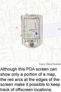
As a person navigates a map on a handheld computer,
the software causes arcs representing selected offscreen locations to
appear on the edge of the screen, as if the locations were surrounded by
circles large enough that a portion of the arc just reached onto the
screen. The user can sense how far away an offscreen location is by the
curve and translucence of its arc, which indicates the size of the full
circle and thus the distance to its center.
The software could make it easier to use small
screens to navigate maps, three-dimensional environments, and keep track
of moving targets like hazards, or even friends, according to Patrick
Baudisch, now a researcher at Microsoft Research.
"Halo is a visualization technique that supports
spatial cognition... by surrounding offscreen objects with rings that are
just large enough to reach into the border region of the display window,"
said Baudisch. "Users can infer the offscreen location of the object at
the center of the ring," he said. The arcs also become more translucent as
they grow larger to give users a second distance clue.
The researchers hit on the idea while trying to use
small dots at the window border to show distance. "Then I thought of
street lamps and how they cast a halo of light onto the street," said
Baudisch.
There are several other methods for
providing offscreen information on small-screen devices, including
overviews with detailed insets, fisheye views, and arrows. However, insets
divide the user's attention, fisheye views distort distances and
directions, and arrows fail to provide distance information, said Baudisch
The researchers tested their prototype
software with 12 study participants who used it on a laptop and a
relatively large handheld computer. The participants compared Halo and a
second program that used arrows to point to offscreen objects.
The participants carried out four tasks: estimating
where an offscreen object would lie in space, locating the closest of
several offscreen objects, selecting five offscreen targets in the order
that would form the shortest delivery path, and selecting a route to the
closest of several on- and offscreen hospitals that would best avoid
several on- and offscreen traffic jams.
The
participants rated the difficulty of the tasks and the ease-of-use of the
interfaces. The participants performed the tasks 16 to 33 percent faster,
and a majority preferred the Halo interface for each of the four tasks,
according to Baudisch.
Error rates were
slightly lower for the Halo interface on the second, third and fourth
tasks, but somewhat higher on the first task, even though 80 percent of
the participants said they preferred Halo for that task. "The difference
in accuracy was caused almost exclusively by subjects underestimating
distances when using the Halo interface," said Baudisch.
The researchers are currently working to change the
circles to ovals, which may allow people to perceive distance more
accurately, Baudisch said. They are also working on a three-dimensional
version of the software, he said.
The method
could solve a potential problem in navigating complicated environments
through a small handheld computer screen, according to Baudisch. "If I
use... editing tools to move a graphical object around in [a] potentially
infinite plane, how can I make sure I find it again?" he said. "Halo
could... solve the problem."
The researchers
are also working to adapt the method to real-time environments. "Halo gets
really useful if offscreen objects move or change their relevance," said
Baudisch. "Think of a handheld system that informs you about the
availability of attractions in a theme park [or] hazards in a hostile
environment."
On a handheld connected to a
wireless network, halos could also represent the movements of people, for
instance, the users' friends, Baudisch said.
The method is also appropriate for games, said
Baudisch. "Think of a football game -- where are my teammates? -- is a
player of the opposite team at a location where he or she could intercept
my pass?"
The basic method is ready for
practical use now, said Baudisch.
Baudisch's
research colleague was Ruth Rosenholtz of Palo Alto Research Center. They
presented the research at the Association of Computing Machinery
Computer-Human Interaction (ACM-CHI) conference in Fort Lauderdale,
Florida in April 5-10, 2003. The research was funded by PARC Inc.
Timeline: Now
Funding:
Corporate
TRN Categories: Human-Computer
Interaction
Story Type: News
Related Elements:
Technical paper, "Halo: A Technique for Visualizing Offscreen
Locations," presented at the Association of Computing Machinery (ACM)
Computer-Human Interaction (CHI) Conference 2003 Fort Lauderdale, Florida
April 5-10, 2003, and posted at
www.ipsi.fhg.de/~baudisch/Publications/2003-Baudisch-CHI03-Halo.pdf.
Page
One Archive Glossary Resources Research
Directory
Newsletters and
Reports TRN Store Feedback Letters Comments
Find
out about TRN Services for Web sites
and print publications.
About
TRN
© Copyright Technology Research News, LLC 2000-2003. All rights reserved.